New Village at Murrell Green

Delivery Strategies
Access and Movement Strategy
The draft proposals include four detailed access points.
-
A30 North-Western Access (located between Hook and the Murrell Green Business Park).
-
A30 Northern Access (located between Murrell Green Business Park and Totters Lane).
-
A30 North-Eastern Access (located approximately 140m east of Totters Lane).
-
B3016 Odiham Road Access (located approximately 160m north of the B3016 / Old Potbridge Road junction).
The access and movement strategy establishes connections to the surrounding transport network whilst prioritising sustainable and active modes of travel. The site benefits from immediate links to the A30 and B3016. However, the plan recognises that these major routes also bring challenges in terms of noise, accessibility and the need for safe crossings, all of which will be carefully addressed.
The movement framework has been designed around a hierarchy of streets, with a primary east–west route forming the main ‘spine’ through the development and connecting to the wider network. Secondary and local streets branch from this to discourage through-traffic while encouraging walking and cycling for local journeys. Walking and cycling routes are integrated into the green corridors and connect with the existing public rights of way, ensuring that residents can move easily and safely through the village and out into the surrounding area. Public transport and access by sustainable modes have been key considerations from the outset. Winchfield railway station, which provides regular connectivity between Basingstoke and London Waterloo, will be within walking distance of the east of the site and cycling distance of the wider development. The spine road is designed to enable the rerouting of existing bus services from the A30, improving accessibility to Murrell Green and preventing reliance on private cars.
Some sections of Totters Lane will be downgraded to walking and cycling only in order to retain their rural character while maintaining access to existing properties. For this reason, we anticipate preventing through vehicular traffic either side of the rail bridge at Totters Lane. Turning spaces will be provided for vehicles where the road is closed to vehicle traffic. This will mean that vehicle access to the sports provision and Suitable Alternative Natural Greenspace south of the railway line will only be from the south.
Car and cycle parking will be provided for each property. Visitor cycle parking will also be provided for the local centres, schools, employment uses and key public open space destinations.

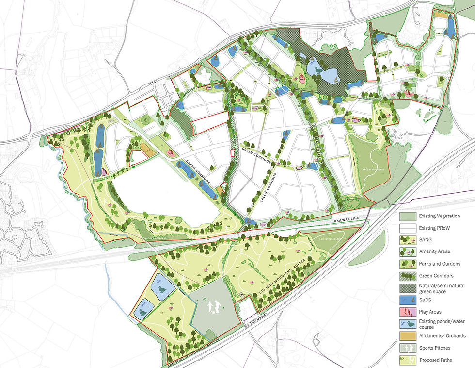
Landscape Strategy
The design of the Murrell Green masterplan is landscape-led, placing the natural environment at the heart of the new village. Around 45% of the site will be dedicated to green space, including natural and semi-natural green space, public parks, allotments and other forms of green spaces. Key streets will be tree-lined or integrated into wider green corridors.
Green spaces throughout Murrell Green will be designed to be both beautiful and productive. Smaller green corridors along walking and cycling routes will incorporate pocket orchards and allotment gardens, while larger areas will feature wildflower meadows and habitats for wildlife. These spaces will connect seamlessly to the wider green network and the extensive areas of over 50 hectares of Suitable Alternative Natural Greenspace (SANG) around the edges of the development. Along the southern boundary, extensive woodland and landscape will be retained as an effective visual and acoustic buffer from the railway and M3 motorway.
The hard landscape at Murrell Green will be guided by principles of simplicity, longevity and a strong sense of place. Materials and details will take their cue from the surrounding villages of Hartley Wintney, Odiham and Hook, where greens, commons and high streets are characterised by traditional surfaces, understated furniture and a balance of rural and village life.
Water Strategy
The extreme western edge of the site is formed by the valley of the River Whitewater and is therefore affected by flood risk. The site is otherwise free of flood risk associated with water courses. Surface water flooding is not prominent, but there are some areas near the A30 where water collects and ponds.
The site geology consists of bands of Sedimentary Sand, London Clay and Sand, Silt and Clay formations. As a result, rainfall runs off across these slowly permeable soils with some infiltrating and the rest draining to the River Whitewater and the local ditch network.
The development will deploy a range of sustainable drainage techniques to ensure that surface water is stored and transferred to the existing natural surface water systems in an appropriate manner. This will include for example open swales and attenuation ponds. These features would manage the surface water run-off, and also provide additional community and environmental benefits – notably to biodiversity, water quality, landscape and recreational amenity.
They will also ensure that flood risk elsewhere would not be impacted by development of the site, with obligations to design for future climate change scenarios that will provide a betterment over existing discharge rates. Foul sewage would connect into the existing public sewer with a pumping station provided to connect into the wider system.
Ecology Strategy
Murrell Green is predominantly grassland and woodland, with several ponds, including Shapley Fishing Lakes, close to the A30. Several mature trees and hedges frequent the landscape, with the alignment of Brenda Parker Way being a strong linear feature, comprising a section of holloway. Areas of Ancient Woodland are found within the site, alongside other non-designated areas of woodland.
The features of the landscape have the potential to support protected and notable species, and a suite of specialist surveys have been completed to inform the design. This has identified corridors to protect bat populations and ancient woodland, amongst other ecological interests.
The development itself will provide for nesting opportunities within the development (e.g. swift bricks) and safeguard green corridors to connect wildlife.
Proposals will need to avoid, mitigate and compensate for any habitats and species that could be harmed. At least 10% biodiversity net gain will be achieved as required under the Environment Act 2023.
New areas of Suitable Alternative Natural Greenspace will provide over 50 hectares for attractive recreational walking routes to safeguard the protected habitats of the Thames Basin Heaths. These areas will also provide extensive opportunity for wildlife enhancements.


Architecture & Built Form
The design of the proposed buildings will be agreed at reserved matters stage. However, the intention at this outline stage is to establish a framework for the delivery of architecture and built form which is in communion with the past, the present and the future.
A Strategic Design Code will be agreed with Hart District Council that will set out the framework of streets and parcels of development that will help guide the detailed content within the subsequent reserved matters applications.
Built form in the masterplan is derived from the movement hierarchy, green spaces and local centres. A range of housing will be provided from one bedroom flats up to detached family homes.
There is a primary centre, slightly to the east of the physical centre and at the junction of the two primary routes. This forms the heart of Murrell Green and is where most amenities and social uses will be located. This is where higher densities could be located, with 3 storey flats and terraces the most common building type.
There is an important secondary centre slightly to the west beside the proposed school. Density decreases away from the centres and primary routes, but townhouses could also be provided, where suitable, to frame and overlook areas of public open space.